
50m²
Honeymoon Suite
Cave suite with caldera-facing veranda — designed for couples and milestone trips.
View room
Travel Guide
By Fanis Kafouros, Owner since 2006 · Updated March 2026
Santorini is a crescent-shaped island just 18 km long and 5 km wide. The western cliff edge (the caldera rim) holds the famous sunset-view towns: Fira, Oia, Imerovigli, and Firostefani.
Quick Answer: Santorini is a crescent-shaped island roughly 18 km long and about 7 km across at its widest point, narrowing to just a few kilometres along much of its length. The western cliff edge (the caldera rim) holds the famous sunset-view towns: Fira, Oia, Imerovigli, and Firostefani. The eastern and southern coasts are flatter, with black sand beaches like Kamari and Perissa. Fira sits at the center and is the island's transport hub. You can drive from one end to the other in about 30 minutes.
Look at a santorini map for the first time and you'll probably have the same reaction everyone does. Confusion.
It doesn't look like a normal Greek island. Not round, not square, not even one continuous piece of land. It's a broken crescent wrapped around a flooded volcanic crater, and that strange shape explains almost everything about how the place works, where the views are, why some towns are famous and others are ignored, how to plan your days without wasting hours going back and forth. This is part of our Santorini travel guide, and it walks you through the santorini island map zone by zone so you know the layout before you even land.
For an interactive view, open Santorini on Google Maps.
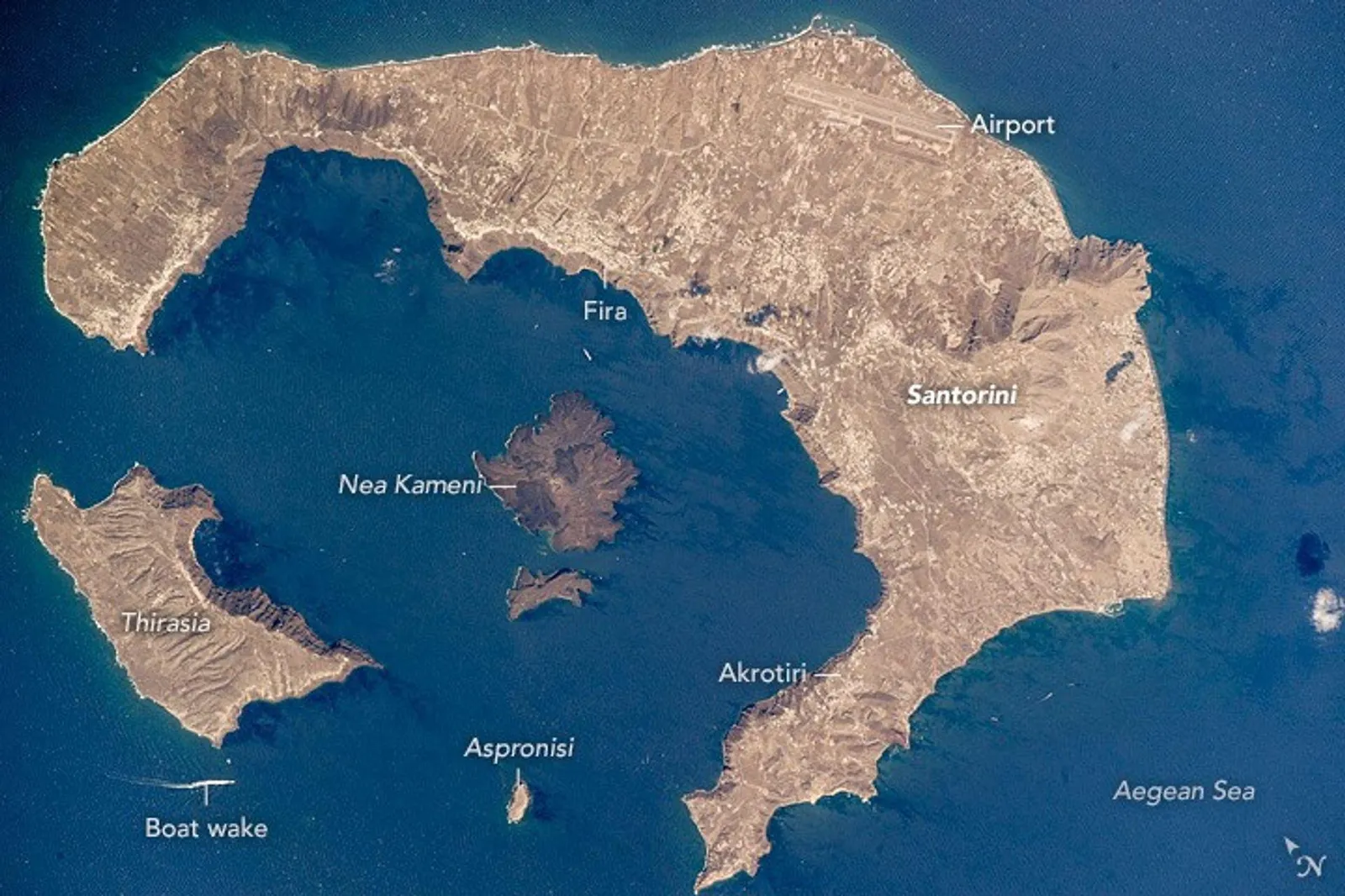
Santorini isn't a typical island. What shows up on a map of santorini greece is the eastern rim of a massive volcanic caldera, the aftermath of one of the most powerful eruptions in recorded history. The Minoan eruption, roughly 1600 BC. The center of the original island collapsed. The sea rushed in.
Today it looks like this:
This caldera shape is why Santorini has two completely different coastlines. The western edge (the caldera rim) is a sheer cliff dropping 300 meters straight into the sea. That's where the views are, where the whitewashed cave hotels cling to the rock, where sunsets turn everything amber. The eastern and southern coasts slope gently down to sea level. That's where the beaches are.
Understanding that split is the single most important thing for reading a santorini map.
The caldera rim runs along the entire western side, from Akrotiri in the south to Oia at the northern tip. Four towns sit along it. Together, they are the Santorini from every postcard, every Instagram reel, every sunset photo you've ever seen.
Fira is the capital. The logistical heart. It sits roughly at the midpoint of the caldera rim, perched on cliffs about 260 meters above sea level. Every bus route starts and ends at the Fira bus station. That alone makes it the natural hub for getting anywhere.
What Fira has that the other caldera towns don't: range. Caldera-edge restaurants with volcano views. Cocktail bars. Museums. Shops. A cable car down to the old port. The island's only proper nightlife. It's walkable, it's alive, and it's connected. Want to reach every part of the island without a car? Fira is your base.
Aroma Suites sits right here on the caldera rim: cave-style architecture carved into the cliff, unobstructed views across the water to the volcano.
Oia is 11 km from Fira, about 25 minutes by car or bus. It's the most photographed village on the island. The blue-domed churches. The white windmills. The sunset crowds at the castle ruins. All Oia.
Beautiful, and it knows it. The main marble walkway is lined with galleries, jewelry shops, restaurants. It's a different experience from Fira: more polished, more expensive, significantly more crowded during sunset hours. Makes for a perfect half-day visit from Fira. Don't stay there unless your budget runs double what Fira charges for a comparable room.
Two kilometers north of Fira, Imerovigli sits at the highest point on the caldera rim. Quieter. More residential. A handful of excellent hotels and restaurants but not much shopping or nightlife.
The draw: Skaros Rock. A dramatic rocky headland jutting into the caldera. Hike out to the tip for some of the most expansive views on the island. Also one of the best-kept sunrise spots.
Firostefani is wedged between Fira and Imerovigli. So close to Fira that the two practically merge, the caldera walk between them takes about 10 minutes. You get the quiet atmosphere of a smaller village with the convenience of being a short stroll from everything in Fira.
That iconic Santorini photograph, a blue-domed church against the caldera backdrop? Taken here. The Three Bells of Fira church.
Flip to the other side of the santorini map and the landscape changes completely. Flatter. More accessible. Lined with beaches. No dramatic cliffs. No caldera views. But a completely different side of the island that's worth your time.
Most organized beach town on the east coast. About 10 km southeast of Fira (15 minutes by car). Long stretch of black volcanic sand, a paved promenade with restaurants and bars, lounger rentals, an open-air cinema in summer.
More relaxed and family-friendly than the caldera towns. Sits at the base of Mesa Vouno, the mountain that also holds the Ancient Thera ruins. The airport (JTR) is only 3 km away.
Perissa and Perivolos share a continuous black sand beach stretching nearly 7 km along the southeastern coast. About 14 km from Fira (20 minutes). Perissa is the more established section, beach bars, tavernas, water sports. Perivolos, further south, draws a younger crowd with its clubs and DJ sets.
These beaches sit on the opposite side of Mesa Vouno from Kamari. Close as the crow flies, but you can't walk between them. Drive around the mountain or take a small boat in summer.
Akrotiri occupies the southwestern tip. Known for three things: the Akrotiri archaeological site (a Minoan settlement buried by the same eruption that created the caldera), Red Beach (striking red volcanic cliffs, dramatic to look at, small and often crowded), and the Akrotiri Lighthouse. That lighthouse? One of the island's best sunset spots with a fraction of Oia's crowds.
Vlychada Beach is nearby too. A surreal stretch of sand beneath sculpted white and grey cliffs that look almost lunar. Worth the drive.
Eastern coast: swimmable beaches. Western caldera side: no beaches at all, just cliffs dropping into deep water. Here are the main beaches from north to south:
Not everything on the santorini town map is on the coast. Several inland villages offer something the tourist-heavy coastline doesn't: quiet. Tradition. A glimpse of what the island is actually like when nobody's posing for photos.
Medieval hilltop village roughly in the center of the island, 7 km from Fira. Used to be the capital before Fira took over. The old kasteli (fortress) at the top gives 360-degree views, caldera, beaches, airport, volcano, all at once.
The village itself is a maze of narrow alleys, stone archways, whitewashed houses. Less polished than the caldera towns. More authentically Greek. A few excellent restaurants have opened in recent years. This is the Santorini you won't find by staying in a resort bubble.
Traditional village about 9 km south of Fira, surrounded by vineyards. Known for old canavas (wine caves), neoclassical mansions, and a central square that feels completely disconnected from the caldera chaos. Several of the island's best wineries are a short drive away.
Want a quiet afternoon wandering a village that still feels lived-in rather than curated? This is the one.
Two spots on the santorini map that confuse newcomers because they're not where you'd expect.
Athinios is the main ferry port, and it's not in any town. It sits on the western cliffs between Fira and Megalochori, a road carved into the cliffside with a dock at the bottom. When your ferry arrives, you're at the base of a steep, winding road. Buses, taxis, and transfers meet ferries at the top.
About 10 km south of Fira (20 minutes by car). Don't confuse it with the Old Port in Fira, that's the small harbour at the bottom of the cable car. Old Port is only for cruise tenders and volcano tour boats.
The airport sits on the eastern side near Kamari and Monolithos village. Tiny. One runway, limited terminal. Gets overwhelmed in peak season. But it's only 6 km from Fira (10 minutes by car), so transfers are quick wherever you're staying on the caldera.
Fira sits at the center, so it's the natural reference point. Santorini is only about 18 km long (a few kilometres wide for most of its length). End to end in about 45 minutes.
| Destination | Distance from Fira | Driving Time |
|---|---|---|
| Oia | 11 km | ~25 min |
| Imerovigli | 2 km | ~5 min |
| Firostefani | 1 km | ~3 min (or 10 min walk) |
| Kamari Beach | 10 km | ~15 min |
| Perissa Beach | 14 km | ~20 min |
| Akrotiri / Red Beach | 12 km | ~20 min |
| Pyrgos | 7 km | ~12 min |
| Megalochori | 9 km | ~15 min |
| Airport (JTR) | 6 km | ~10 min |
| Athinios Port | 10 km | ~20 min |
| Vlychada Beach | 13 km | ~20 min |
A note on driving times: These assume normal traffic. In July and August, add 5-10 minutes to anything passing through Fira or Oia. The road through Fira bottlenecks badly during peak hours. If you're planning a 3-day itinerary, group destinations by area to avoid zigzagging across the island.
Santorini's public bus system (KTEL Santorini) runs a hub-and-spoke model centered on the Fira bus station. This is the single most important thing to understand about public transport here: every route starts or ends in Fira. You cannot go directly from Oia to Perissa, or from Kamari to Akrotiri, without changing in Fira.
Main routes from Fira:
Fares: EUR 2.20-2.80 depending on route (paid in cash to the conductor on board). Summer service runs roughly 7 AM to 11:30 PM. Reduced in off-season.
The practical takeaway: Stay in Fira and every bus is at your doorstep. Stay in Oia, Kamari, or Perissa, and you'll need to transfer in Fira for any cross-island trip. This is a big reason why first-time visitors choose Fira as their base.
One of the best ways to understand the santorini island map is to walk it. The caldera path follows the cliff edge from Fira to Oia, roughly 10 km, connecting all four caldera towns.
The accessible section. Mostly paved, gently rolling, caldera views the entire way. Through Firostefani in about 10 minutes. Into Imerovigli in 45-60 minutes depending on how often you stop. You'll stop often. The views keep getting better.
Manageable for most fitness levels. Comfortable shoes, water, and go in the morning or late afternoon to avoid summer midday heat.
After Imerovigli the path gets real. Less defined. Rocky scrambles. Steep elevation changes. Spectacular scenery, wild, dramatic, far less crowded. But this is a proper hike, not a stroll.
Bring plenty of water. Proper shoes (not sandals). Start early. The full Fira-to-Oia walk takes about 3-3.5 hours. Most people take the bus back from Oia.
Full route breakdown in our Santorini hidden gems guide.
Everyone is surprised by how small Santorini is. The numbers:
For comparison: a little larger than Manhattan, and you could fit London's entire congestion charge zone inside it more than three times over. Farthest two points (Oia to Akrotiri Lighthouse) are about 45 minutes apart by car.
The upside: you don't have to commit to one part of the island. Staying in Fira and want a morning at Perissa Beach? Twenty-minute drive. Catch sunset in Oia and be back for a late dinner in Fira? Easily done. The 3-day itinerary we recommend covers the entire island without ever feeling rushed, precisely because nothing is far from anything else.
Group your Santorini days by geography, minimize driving, maximize time:
Caldera Day: Morning exploring Fira. Walk the caldera path to Imerovigli. Afternoon at Skaros Rock. Sunset from the path or a caldera restaurant. Everything on foot. No transport needed.
Oia Day: Bus or drive to Oia early morning (before the crowds arrive). Explore the village, browse galleries, lunch with a view. Ammoudi Bay for a swim or seafood. Famous Oia sunset. Bus back to Fira.
Beach Day: Morning at Perissa or Kamari. Beachfront taverna for lunch. Afternoon at Vlychada or Red Beach (both within 15 minutes by car). Squeeze in the Akrotiri archaeological site if you start early enough.
Wine and Villages Day: Pyrgos village in the morning. Wine tasting at 2-3 nearby wineries, Argyros, Venetsanos, Santo Wines are all in the same area. Megalochori for a quiet late lunch. This is the inland Santorini that most tourists completely miss.
About 73 square kilometers (28 square miles), roughly 18 km north to south and up to 5 km east to west at the widest point. You can drive from Oia (far north) to Akrotiri (far south) in about 40 to 45 minutes without traffic. Despite the small size, the cliff-and-caldera geography makes distances feel longer than the map suggests. Despite the small size, the cliff-and-caldera geography makes distances feel longer than the map suggests.
Santorini sits in the southern Aegean Sea, the southernmost of the Cyclades island group, about 200 km southeast of mainland Greece and 130 km north of Crete. It is part of the South Aegean administrative region and the Thira regional unit.
The caldera side, the western cliff, has the iconic views. Within it, Fira (lively, central, well-connected), Imerovigli (quiet, romantic, highest point on the island), and Oia (most photogenic, busiest at sunset) are the main options. The eastern side, Kamari and Perissa, offers beach access at lower prices but no caldera view. See our where to stay guide for a deeper breakdown.
Five towns sit on the caldera rim: Fira (capital), Firostefani, Imerovigli, Oia, and the smaller villages of Megalochori and Pyrgos inland. The eastern coast hosts Kamari and Perissa (beach resorts). The southern tip has Akrotiri (the archaeological site) and the lighthouse. Each has a distinct character.
Santorini is the rim of a sunken volcanic caldera. Around 1600 BC the Minoan eruption blew the center of the island into the sea, leaving the crescent (Thira), a smaller island opposite (Thirassia), and a volcanic islet in the middle (Nea Kameni). See our Santorini caldera guide for the full geological story.
No single official map exists. Google Maps works well, but download the offline version before you arrive. Cell signal gets unreliable deep in the caldera cliffs, especially on the walking path between Imerovigli and Oia. Pin your hotel, the Fira bus station, and the port while you have Wi-Fi.
About 40-45 minutes from the northern tip (Oia) to the southern tip (Akrotiri Lighthouse), allowing for the island's narrow, winding caldera roads. The island is only 18 km long, but the cliff-and-caldera geography makes distances feel longer than the map suggests. From Fira, nothing is more than 25 minutes away.
Caldera (west) side: famous views, sunsets, cave hotels. East side: beaches, more affordable accommodation. For first-time visitors, we recommend the caldera side, specifically Fira. You get the views and easy access to every corner of the island.
Yes. Roughly 10 km, 3-3.5 hours. First section (Fira to Imerovigli) is easy and paved. Second section (Imerovigli to Oia) is a serious hike over rocky ground. Most people walk one direction and bus back.
Athinios Port, on the western cliffs about 20 minutes south of Fira. Not in any village, just a dock at the base of steep switchbacks. Buses and taxis meet every ferry. Don't confuse this with the Old Port below Fira (cruise tenders and day-trip boats only). More on getting here in the Visit Greece Santorini guide.
*Fira sits at the center of Santorini, the ideal base for reaching every corner of the island.
Planning a Santorini trip?
Get our insider guide
Local tips, hidden spots, and an exclusive direct booking discount delivered to your inbox.
Stay with us
Six cave-style suites on the caldera in central Fira. Direct booking includes complimentary wine on 3+ night stays and free airport transfer on 4+ nights.
Cave suite with caldera-facing veranda — designed for couples and milestone trips.
View room
70m² cave suite with year-round heated indoor jacuzzi and arched ceilings.
View room
Heated outdoor jacuzzi on a private balcony — caldera and sunset, no shared spaces.
View roomYour Stay Awaits
Experience Santorini from a cave suite perched on the caldera edge in Fira.